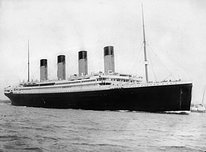
The Titanic – Maiden Voyage Mapping Task

Group Task
Part 1: This task requires you to research information using only the links below and our class atlases.
In pairs, group members must complete a blank map of the Titanic’s journey, identifying the main locations relevant to:
- her construction
- maiden voyage
- sinking
- rescue of the survivors.
This information should then be transferred to your larger group map.
Southern Ireland
New York
Northern Ireland
England
France
The location of the iceberg will be given to you when you return to class.
_inside.png)
Last week for our Brazil topic we had to find our where Brazil was in the world in relation to Scotland. We also had to research and find a number of important locations within Brazil and its bordering countries. What fun can be had with Google Maps!
Once we had individually recorded the information on our own maps, we transferred it to a larger group map which is now on our wall space in class. A few of our new groups need to work on their listening skills as the Pacific Ocean seems to have flooded some of Brazil’s bordering countries on the maps. Well done to the groups who realised their mistake and fixed it in time.
Please show someone at home your completed map and tell them some information about the locations on your map. Which city is the capital of Brazil? Which is the largest city in Brazil? Can you remember how many people live there? Where are Scotland and Brazil located on the map?
Old Greenock Road, Bishopton, PA7 5BE


_inside.png)


